
Tokyo Metro extensions approved
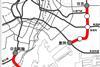
JAPAN: The Ministry of Land, Infrastructure, Transport & Tourism has given Tokyo Metro the go-ahead to develop two proposed extensions to the capital’s metro network.
You’ve reached your limit of content for the month
Get enhanced access to Railway Gazette news and weekly newsletters.

For almost 200 years, the Railway Gazette Group has been the leading provider of news, analysis and intelligence for the international railway industry. Our independent and authoritative content is read by operators, regulators and the supply industry in over 140 countries using a variety of tailored subscription packages.