- News
- In depth
- Events
- Data
- Maps
- Tenders & Jobs
 Tender No. 42244 For the Manufacture and Supply of Turnouts and Tracks Geometry Measurement Trolley (“Tender”)
 RFP No. 42247 Provision of Consulting Services in Various Railway Fields for Israel Railways (RFP)
 Tender 42230 - Supply of Forklifts and Reachstacker for ISR’s Cargo Division
 Timetabling & Track Possession System (“Tender”)
- Sponsored content
- Insights
Close menu
- Home
-
News
- Back to parent navigation item
- News
- Traction and rolling stock
- Passenger
- High speed
- Freight
- Infrastructure
- Policy
- Technology
- Ticketing
- Business
- Research, training and skills
- Accessibility and inclusion
- People
- Urban rail news
- Suburban and commuter rail
- Metro
- Light rail and tram
- Monorail and peoplemover
- Regions
- InnoTrans
- In depth
- Events
- Data
- Maps
- Tenders & Jobs
- Sponsored content
- Insights


Identifying ‘navigational hazards’ on metro maps
By Railway Gazette International2018-05-18T09:00:00
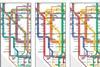
MAPS: It might be possible to use software to automatically detect features of metro maps which cause passengers to make mistakes in journey planning, researchers believe.
Already have an account? LOG IN
To continue…
You’ve reached your limit of content for the month