


All Osaka articles
-
-
Organisations
Osaka Kosoku Tetsudo
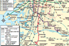
Initial section of this straddle monorail opened 1990. Two routes serving 18 stations. See Osaka network map. Links Osaka airport and Kadomi-shi across north and northeast Osaka, with four connections to Osaka metro lines. A 6·8 km branch north from Banpaku-Kinen-Kōen to Saito-nishi (the Saito line) serves Osaka university hospital. ...
-
Organisations
Osaka-shi Kotsu Kyoku
First line opened 1933. Network now comprises 8 lines with 103 stations plus peoplemover. See Osaka network map. The metro provides dense coverage in Osaka city centre through a grid of lines, some extending through-running to suburban routes. Osaka Metro LineNamekmstationsopenedlast ext.power systemnotes 103 stations on ...
-
Organisations
Hankai Denki Kido
First line opened 1900; two-route tramway serving 39 stops. See Osaka network map. Wholly-owned by Nankai Electric Railway, the tramway serves south Osaka and Sakai city. The main Hankai line runs from Ebisucho on Osaka metro’s Sakaisuji line south via Sumiyoshi to Hamadera (14·1 km). The Uemachi line connects Tennoji ...