


All San José articles
-
 Country profile
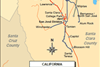
USA: Caltrain - project map
USA: Caltrain electrification project map – rail upgrade map
-
 Country profile
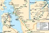
San Francisco, Oakland & San José - city map
San Francisco, Oakland & San José, USA: urban area rail network map
-
Organisations
Santa Clara Valley Transportation Authority (VTA)
First line opened 1987. Three-line network serving 60 stops. See San José network map. From December 28 2019 the branch from Ohlone-Chynoweth to Almaden (1·8 km, 2 stops) was closed, with services restructured. The network is now operated as three routes; services from the Winchester (southwest) and Santa Teresa (southeast) ...
-
Organisations
Bay Area Rapid Transit (BART)
First line opened 1972; metro network now comprises 5 lines with 46 stations.See San Francisco network map. The initial programme of construction linking Fremont, Richmond, and Concord to Oakland and the Transbay Tunnel to San Francisco and Daly City, was completed in September 1974. Extensions in 1996-97 took the Concord ...