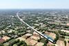


SAVING on the cost of construction can make the difference between a project going ahead or being scrapped. Australia’s government scientific agency SCIRO has developed with Quantm Ltd an advanced computer-based tool to define the most cost-effective alignment, and this is already being put to use on the West Angelas line in the Pilbara and on the planned Alice - Darwin route. It has also been applied to the proposed 220 km Sydney - Canberra high speed line, allowing a reduction in the steepest grade from 4% to 3·2%, giving a significant saving in building cost.
First step is to obtain geospatial images of the development corridor using satellites or other airborne platforms. These are supplemented by laser profiling, which can give an accurate picture of the ground beneath trees or under water. Hyperspectral analysis can be used to determine soil types and flora in considerable detail. All this information is used to build a comprehensive three-dimensional map in virtual reality.
The customer then enters the virtual world to complete the picture by inputting technical, environmental and social data. The various construction parameters are specified, and the system can then generate the optimum alignment for a new line. This can be viewed as a virtual reality ’drive through’ and in a variety of other ways, for use by the customer and also in public consultation.
The system minimises the volume of cut and fill and the number and extent of major structures such as bridges and tunnels, achieving typical construction cost savings of 20% compared with conventional methods. The process may be used to develop or even replace environmental impact statements.
A conventional route planner may take a week to prepare an alignment for a 10 km section; Quantm’s system has achieved 200 km in four weeks.
Quantm Ltd, Australia.
Reader Enquiry Form 144